
The Definitive Guide to the Mardi Himal Trek: Itinerary, Costs & Safety
To truly beat standard commercial tour pages, a guide must go beyond generic itinerary lists and sales pitches. It needs to provide real, actionable depth—addressing actual trail costs, precise physical preparation, navigation safety, and a direct side-by-side comparison of trekking styles.
Below is the definitive, high-performance guide to the Mardi Himal Trek, structured to capture search intent and serve as the ultimate resource for hikers.
Quick Reference: Mardi Himal Trek Fast Facts
| Trip Duration | 4 to 5 Days (from Pokhara) |
| Maximum Altitude | 4,500 meters (14,763 feet) at Mardi Himal Base Camp |
| Trail Grade / Difficulty | Moderate to Challenging (Steep inclines and stone stairs) |
| Starting Point | Kande Village (1-hour drive from Pokhara) |
| Ending Point | Siding Village (Drive back to Pokhara) |
| Permits Required | ACAP Permit & TIMS Card |
| Best Seasons | Spring (March to May) & Autumn (September to November) |
| Accommodation Type | Traditional Mountain Teahouses (Lodges) |
Strategic Comparison: Mardi Himal vs. Poon Hill vs. ABC
Choosing the right trek in the Annapurna region depends heavily on your timeline, fitness level, and desired experience.
| Feature | Mardi Himal Trek | Ghorepani Poon Hill | Annapurna Base Camp (ABC) |
|---|---|---|---|
| Duration | 4–5 Days | 2–3 Days | 7–10 Days |
| Max Altitude | 4,500m | 3,210m | 4,130m |
| Crowd Levels | Moderate / Tranquil | Extremely Crowded | High |
| Terrain Style | Exposed, sharp ridge lines | Forested stone stairs | Deep river valleys & gorges |
| Primary Visual | Face-to-face with Machapuchare | Distant panoramic sunrise | Amphitheater of high peaks |
Guided vs. Unguided (Solo) Trekking: The Honest Truth
Many commercial agencies claim you must hire a guide to survive the Mardi Himal trail. The reality is more nuanced:
- The Case for Solo/Independent Trekking: The Mardi Himal trail is highly visible and deeply carved. It features clear, color-coded route markers (typically painted onto trees and rock faces at crucial junctions). If you possess basic fitness, carry an offline GPS map (like AllTrails), and stick to daylight hours, navigating independently is entirely achievable.
- The Case for Hiring a Guide/Porter: If you have zero high-altitude experience, struggle with a 12–14 kg pack on your back, or plan to trek during deep winter when snow accumulation hides trail markings, a local guide provides vital safety and logistics management.
The Master 5-Day Itinerary (AMS-Friendly & Optimized)
While seasoned trail runners can compress this route into 4 days, a 5-day layout is the gold standard. It provides proper acclimatization transitions, protecting you from Acute Mountain Sickness (AMS) as you rapidly cross the 4,000-meter threshold.
Route: Pokhara ➔ Kande ➔ Deurali ➔ Forest Camp ➔ High Camp ➔ Base Camp ➔ Siding ➔ Pokhara
Day 1: Pokhara to Kande (Drive) & Trek to Deurali
- Distance: ~5.5 km
- Time: 4 to 5 hours
- Elevation Change: 1,770m (Kande) to 2,100m (Deurali)
Your trek kicks off with a steady uphill climb out of Kande Village. The elevation gain here is gradual but persistent. If you are tracking without a porter, this is where your body adapts to carrying a heavy rucksack.
After about 1.5 to 2 hours of walking, the trail breaks out into an expansive, grassy clearing known as Australian Base Camp (Thulo Kharka). This is the premier lunch spot for Day 1. Order a hot plate of Dal Bhat (the staple local meal of rice, lentil soup, and vegetable curry) and a cup of milk tea.
From Australian Base Camp, you pass through the village of Pothana and continue a gentle, scenic ascent through lush woodlands until you hit the small ridge settlement of Deurali.
Stay Information: Deurali features clean, budget-friendly teahouses. A standard twin-sharing room runs around ₹1,000 NPR and often includes an attached washroom. From your porch, you will look out over a vast sea of clouds.
Day 2: Deurali to Forest Camp (Kokar)
- Distance: ~7 km
- Time: 5 to 6 hours
- Elevation Change: 2,100m to 2,990m
Leaving Deurali, the route leaves the main village trails and turns sharply north along a heavily forested ridge line. The climate cools significantly here as you enter a deeply atmospheric jungle zone.
On this segment, you will experience the famous volatility of Himalayan weather. The morning typically starts clear, but by early afternoon, thick mist can roll through the tree canopy, reducing your trail visibility to a few meters. Sudden afternoon rain showers or localized hailstorms are common.
Keep your rain shell handy and use trekking poles to maintain balance on the wet, muddy roots and slick limestone rocks. The day ends in the peaceful clearing of Forest Camp, a small cluster of lodges nestled deep inside the woods.
Stay Information: Lodging here is basic but cozy, costing around ₹450 to ₹500 NPR per person for a room. Most teahouses feature great west-facing clearings to watch spectacular sunsets over the Annapurna South and Hiunchuli peaks if the mist breaks.
Day 3: Forest Camp to High Camp
- Distance: ~6 km
- Time: 6 to 7 hours
- Elevation Change: 2,990m to 3,550m
Day 3 is a physical and mental crucible. You face a punishing 1,000-meter vertical elevation gain over a relatively short distance, completely ascending out of the tree line.
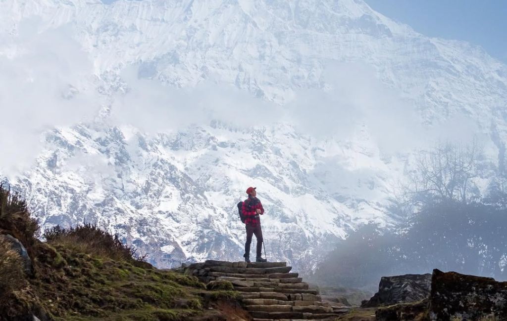
The defining characteristic of this day is the endless stone stairs. Local builders have meticulously laid thousands of hand-carved stone steps along the ridge. While this keeps the path well-defined, stepping upward continuously with a heavy pack puts massive strain on your quadriceps and calves.
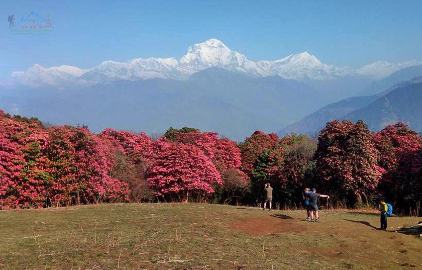
The Landscape: If you trek in the spring, you are treated to a magnificent sight: the entire ridge becomes a blanket of blooming pink, white, and crimson Rhododendron forests (Laliguras). As you climb past Low Camp, the trees shrink into sub-alpine juniper bushes, and you reach Badal Danda (Cloud Ridge).

The trail opens up completely onto a narrow, exposed ridge line. If the clouds roll in, the drop-offs on either side disappear into a blank white void. Push through the cold wind and thin air to check into your lodge at High Camp.
Day 4: High Camp to Mardi Himal Base Camp & Descent to Siding
- Distance: ~14 km (total loop + descent)
- Time: 7 to 9 hours
- Elevation Change: 3,550m to 4,500m (Base Camp) then down to 1,750m (Siding)
This is your summit day. Alarms go off in the freezing cold at 4:00 AM.
The Summit Strategy: Because you will return to your High Camp lodge to pick up your gear, you can leave your heavy rucksack behind. Carry only a light daypack with water, snacks, an insulated jacket, and your camera. Hiking light allows you to tackle the steep, technical terrain with much more speed and safety.
As you navigate the narrow ridge trail under the morning twilight, look back: you will see a spectacular sunrise hitting the face of Annapurna South, while the moon sets behind you.

The Final Ridge to Base Camp (4,500m): For those making the final push to the official Mardi Himal Base Camp, the trail turns into a rugged, high-alpine track. The morning sun begins to melt the overnight ice, making the dirt and rock sections slick and slippery. If you do not have microspikes, move with absolute caution. At 4,500m, the oxygen level is thin; your heart will race, and your breathing will be deep. Pace yourself using the "one slow step at a time" rule.
At Base Camp, you will stand directly in front of the vertical, awe-inspiring wall of Machapuchare.
After soaking in the view, retrace your steps back down the steep ridge to High Camp, eat a quick meal, collect your heavy bags, and begin a sharp, steep descent down an alternative route to the village of Siding. This long downhill drop can be brutal on the knees; take your time.
Day 5: Siding to Pokhara (Drive)
- Time: 3 to 4 hours (Jeep ride)
- Elevation Change: 1,750m to 820m (Pokhara)
Wake up to a warmer, rural valley environment. Siding is a traditional Gurung farming village surrounded by terraced rice fields. Enjoy a relaxed breakfast by the Mardi River. From Siding, you will hop into a shared or private local four-wheel-drive jeep. The road is a rugged, unpaved mountain track that winds down along the river valley before meeting the main highway back to Pokhara. You will arrive by early afternoon, leaving plenty of time to relax next to Phewa Lake.
Financial Planning: The Truth About the "Altitude Tax"
Tear down the hidden pricing of agency packages by understanding how the mountain micro-economy actually functions. Every menu along the trail is standard across all teahouses due to local lodge committees. However, food and water prices suffer from a steep Altitude Tax.
Because there are no roads on the ridge line, every single egg, vegetable, and gas cylinder must be physically carried up the mountain steps on the backs of mules or human porters.
The Cost Curve: A plate of Dal Bhat or a bottle of water that costs a baseline price at Kande will increase by roughly ₹50 to ₹100 NPR for every level of altitude you gain. Expect to spend approximately $30 to $40 USD per day on food, hot water refills, and basic electronic device charging at High Camp. Carry all your money in cash (Nepalese Rupees); there are absolutely no ATMs past Pokhara.
Essential Packing & Preparation Blueprint
If you are carrying your own gear, your pack weight must remain under 12–14 kg. Anything heavier will destroy your stamina on the stone staircases.
Essential Hardware
- 45L Technical Backpack: Must have an internal frame and thick padded hip straps to transfer weight off your shoulders.
- Lightweight Trekking Poles: Indispensable for saving your knees during the brutal knee-crushing descent to Siding.
- High-Output Headlamp: Mandatory for navigating the exposed ridge safety gaps during the 4:00 AM summit run.
- Water Treatment System: Pack purification tablets or a micro-squeeze filter. Buying disposable plastic water bottles gets expensive and harms the high-alpine environment.
The Layering Strategy
- Base Layer: Synthetic, moisture-wicking shirts (never wear cotton, as it retains sweat and causes rapid hypothermia when the wind hits).
- Mid-Layer: Grid-fleece jacket for insulation while moving.
- Outer Layer: Windproof/waterproof breathable hardshell jacket, coupled with a high-loft down jacket rated for sub-zero temperatures at High Camp.
High-Altitude Safety & The Sacred Law of Machapuchare
Acute Mountain Sickness (AMS) Realities
Do not underestimate Mardi Himal just because it is a short trek. You are ascending rapidly to 4,500 meters. To prevent altitude illness:
- Hydrate Voluntarily: Drink 3 to 4 liters of water every single day to aid blood oxygenation.
- The Turtle Pace: Never compete or rush up the stone steps. Maintain a slow, uniform cadence where you can speak a full sentence without gasping for breath.
- The Absolute Rule: If a throbbing headache, nausea, or severe dizziness worsens despite rest, you must descend immediately. The mountain ridge has no medical facilities.
Travel Insurance Mandate
Before leaving for Nepal, purchase a travel insurance policy that explicitly covers high-altitude trekking up to 5,000 meters and includes emergency helicopter evacuation. If an unseasonal blizzard strikes or severe high-altitude cerebral edema develops, a helicopter extraction is your only safety lifeline.
The Virgin Peak: Machapuchare

When you reach the final base camp, you will find yourself face-to-face with the spectacular, double-peaked summit of Machapuchare (6,993m), also known as the Fishtail Mountain.
Local Gurung and Hindu communities hold a deep conviction that this isolated peak is the sacred home of the deity Lord Shiva. To protect its spiritual purity, the Government of Nepal has permanently banned all climbing expeditions on the mountain. It remains an extraordinary, completely virgin peak—untouched by human footprints. Approaching this view with reverence is the true core reward of the entire trek.
Frequently Asked Questions (FAQ)
- Can I do the Mardi Himal Trek solo without a guide?
- Yes. The path is deeply carved and exceptionally clear, with distinct color-coded route markers painted onto rocks and trees at key junctions. By using an offline GPS map (like AllTrails) and avoiding hiking past dark, independent trekkers can safely navigate the trail.
- Are there hot showers and Wi-Fi along the route?
- Yes, most teahouses up to Low Camp offer hot gas showers and Wi-Fi access for a nominal fee (typically 200–400 NPR). At High Camp, electricity depends heavily on solar arrays, making connections highly intermittent and facilities far more rustic.
- Is altitude sickness a risk on the Mardi Himal Trek?
- Yes. Because the route ascends steeply from Forest Camp to High Camp, crossing the 3,000-meter mark quickly, some trekkers encounter mild AMS symptoms. If symptoms like persistent headaches or dizziness do not subside with rest, the ultimate rule is to descend immediately.
- How do I get drinking water on the mountain?
- Safe mineral water bottles can be purchased at every single teahouse along the ridge. To reduce costs and eliminate plastic waste in the conservation area, it is highly recommended to bring a reusable bottle paired with a squeeze filter or water purification tablets.
Post a Comment
0Comments